The first work of our
geological department consists in raising a
geological card specifies the concession, marking
the zones where show on the surface the rocky
formations susceptible to be mineralized thus.
This general survey work is often made difficult
by the rarity of the outcrops and the shaggy
vegetation of the bush.
The thick red earth recovery must
sometimes be pierced by small wells. Our
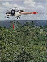
helicopters are of a precious help: the geologist
can overfly without fatigue the zone that he
studies and be deposited close to the outcrops.
The previous exam of aerial photos
(photogéologie) is also very useful, because the
alignments of rocks, and therefore the tectonic
structure of the region, are there often very
visible.
In a second stage, the cartographic geological
department in very big detail the layers marked
by the general surveys. a multitude of small
wells and trenches is dug to determine the shape
and the pendage of the bodies mineralized, as
well as their contents made of metals. Methods of
electric, electromagnetic or magnetic propection
have also been experimented, without big success
up to here.
On the other hand, systematic
measures of radioactivity permitted to discover
some anomalies uranifères; one of them
constitutes a layer.
In a third stage, the geological department that
the layers revealed by the propection of detail
thanks to polls that specify the extension and
the value of ores in depth develop.
In general, one first executes some
polls of recognition. When these last prove to be
interesting, the layer is developed completely by
polls implanted systematically by an adequate
grid. The layer is then very known, and we can
draw it in cuts and in plans of levels, to
calculate the tonnage and the contents of ores
that it conceals.
These evaluations partially make themselves with
the help of an electronic calculator. All these
documents are handed to the engineers of the
mines who will raise the programs of
exploitation.
But the activity of the geologists
doesn't stop there. Indeed, our ores are complex,
and the metallurgists should have distributed
them in numerous categories that undergo each a
different treatment.
He/it is therefore the highest
importance that the miner, during the
exploitation, knows what he charges in
his/her/its skip or his/her/its dump truck
precisely, and the destination to give to this
product.
A division "selectivity"
follows the exploitation from day to day, raise
extremely precise cards of the different types of
ores and guide the miner in his/her/its work.
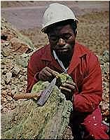
Besides, the geological department
possesses a laboratory of pétrographie, that
studies the minerals, the rocks and ores, and
help of his/her/its advice the geologists of land
and the metallurgists. Some very advanced
techniques are set in motion: chemical analyses,
exam to the microscope of polite faces or thin
sections, exam to the X-rays, thermogravimétrie,
etc...
The activity of the geological department doesn't
limit itself to the only layers. Of other try are
confided to him sometimes, as the research of
aquiferous tablecloths, as well as of the studies
in relation with big works of civil genius (dam
of Busanga, for example)
All observation, all excavation must be marked
precisely. For that to make, we have a
topographic division that establishes the cards,
either by the classic methods of leveling,
triangulation and tachéométrie, either by
aerial or terrestrial photogrammétrie. These
cards are not only used by the geologists, but
also and especially by the direction of the mines
and careers and by the department of the studies
and constructions.
exploitations continue >>
|